Dominican Republic 365
Loading
Dominican Republic 365
Pedernales and Bahia de las Aguilas guide to the 8-kilometer beach, Jaragua National Park flamingos, and the Hoyo de Pelempito canyon.
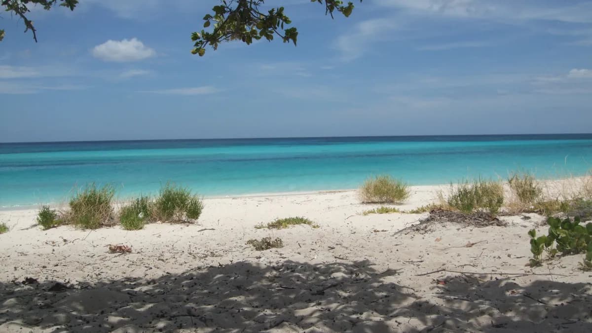
There is a beach at the far southwestern tip of the Dominican Republic that consistently ranks among the most beautiful in the world. It is 8 kilometers long. There are no hotels on it. No beach chairs. No vendors selling coconut oil massages. No trash. No footprints, most days. The sand is so white it hurts your eyes at noon, and the water shifts between shades of turquoise and emerald that look digitally enhanced in photographs but are not. The beach is called Bahía de las Águilas, and getting there requires determination, a sense of adventure, and a willingness to leave the comfortable Dominican Republic behind.
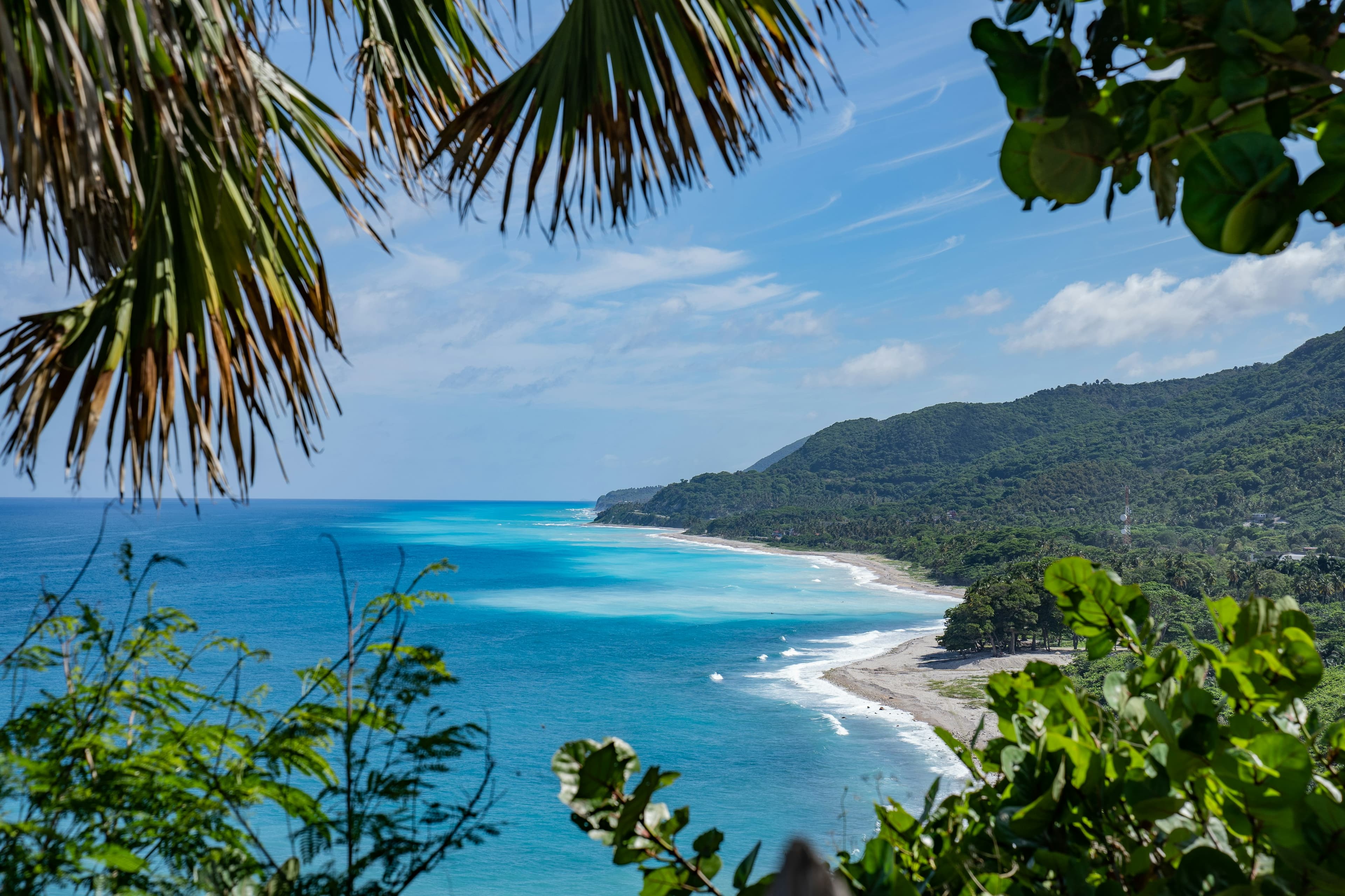
Pedernales is the last province before Haiti, the most remote, least developed, and most spectacularly beautiful corner of the country. The landscapes here look nothing like the rest of the DR: dry thorn forests give way to limestone cliffs, desert-like salt flats, and lagoons teeming with flamingos. This is frontier territory. The roads are rough, the infrastructure is minimal, and the rewards are extraordinary. If you have seen Punta Cana and Santo Domingo and want the real adventure, Pedernales is where you find it.
Pedernales province occupies the Dominican Republic's entire southwestern peninsula, a rugged finger of land bordered by the Caribbean to the south and Haiti to the west. The provincial capital, Pedernales town, has roughly 25,000 residents and sits directly on the Haitian border. This is the least-visited province in the DR, you could spend a week here and not encounter another international tourist.
The region's isolation has been both its curse and its blessing. Economically, Pedernales is one of the poorest provinces in the country. Infrastructure is limited, paved roads only recently reached some parts of the coast, electricity is intermittent in rural areas, and cell phone service drops out regularly. But that same isolation has preserved landscapes that have been lost almost everywhere else in the Caribbean. Jaragua National Park, which covers the southern half of the peninsula, protects the largest remaining tract of subtropical dry forest in the insular Caribbean, along with nesting beaches for hawksbill and leatherback sea turtles, and one of the largest flamingo populations in the Greater Antilles.
The Dominican government has announced plans to develop Pedernales as a sustainable tourism destination, with a new international airport and eco-resort zone planned for the Cabo Rojo area. As of 2026, construction is underway but the area remains largely undeveloped. Visiting now means seeing Pedernales in its raw, pre-tourism state, which is both its greatest attraction and its biggest logistical challenge.
There is no road directly to the beach. Access is by boat from Cabo Rojo, a fishing village about 15 km north of Pedernales town. Here is the step-by-step process:
Alternative access: A rough dirt road does extend to the beach from the Cabo Rojo area, accessible by 4x4 vehicle in dry season (December-April). The drive takes about 40 minutes and requires a high-clearance vehicle. This is not recommended after rain, the road becomes impassable. The boat is more reliable, more scenic, and more fun.
Bahía de las Águilas stretches for approximately 8 km along the southern coast of the Jaragua Peninsula. The claims made about this beach, that it is the most beautiful in the Caribbean, or in the world, are not hyperbole. The sand is fine, white, and powdery. The water is bath-warm and so clear you can see your shadow on the bottom in 3 meters of depth. The seabed is clean sand with patches of sea grass and coral. There are no rocks, no seaweed, no waves to speak of in calm weather, just a gentle lapping at the shore.
What makes Bahía de las Águilas extraordinary is what it does NOT have. There are no buildings, no infrastructure, no vendors, no trash (pack out whatever you bring in), no music, no crowds. On a weekday, you may have the entire beach to yourself. On a busy weekend, there might be 20-30 other visitors spread across 8 km. The backdrop is low scrub forest and limestone hills, no palm trees, which gives the landscape an otherworldly quality more reminiscent of a Greek island than a Caribbean beach.
What to bring: Everything. There is nothing on the beach, no shade structures, no food vendors, no fresh water. Bring an umbrella or portable shade, reef-safe sunscreen, plenty of water (at least 2 liters per person), food, snorkeling gear, and a bag for your trash. The sun is brutal, the white sand reflects UV and you will burn faster than you expect. Bring a hat and a light long-sleeved shirt.
Snorkeling: The reef at the eastern end of the beach is excellent, healthy coral formations with abundant tropical fish. Bring your own gear; there is nowhere to rent it.
Parque Nacional Jaragua is the largest protected area in the Dominican Republic, covering 1,374 square kilometers of land and marine territory. The park encompasses the entire southern portion of the Pedernales peninsula, including Bahía de las Águilas, the islands of Beata and Alto Velo, and extensive coral reef systems.
The terrestrial landscape is dominated by subtropical dry forest, a habitat that once covered much of the Caribbean lowlands but has been almost entirely cleared elsewhere. The forest is dense, thorny, and surprisingly diverse: over 400 plant species have been documented, including many endemics found nowhere else on Earth. Birdwatchers will find the park rewarding, key species include the Hispaniolan parakeet, white-crowned pigeon, rhinoceros iguana, and the critically endangered black-capped petrel, which nests in the park's limestone caves.
Marine habitats include seagrass beds, mangrove forests, and coral reefs that support manatees, sea turtles (hawksbill, green, and leatherback), and dolphins. The park's remote beaches are important nesting sites for sea turtles between May and October.
Entry to Jaragua National Park requires a permit and a guide, obtainable at the park ranger station in Cabo Rojo or the Ministerio de Medio Ambiente office in Pedernales. The fee is RD$200 (US$3.40) per person. Guides are available for approximately RD$1,500-2,500 (US$25-42) per day and are strongly recommended, trails are unmarked and the terrain is challenging.
Laguna Oviedo is a hypersaline lagoon on the eastern edge of Jaragua National Park, approximately 30 km east of Pedernales town along the coastal road toward Barahona. The lagoon is one of the most important bird habitats in the Caribbean, hosting colonies of American flamingos, roseate spoonbills, white ibis, and over 60 other bird species.
Boat tours of the lagoon depart from the ranger station on the north shore. Tours last approximately 1.5-2 hours and cost RD$1,500-2,500 (US$25-42) per boat (up to 4-5 passengers) plus the park entry fee. The flamingos are most reliably seen between December and April, when flocks of 50-200+ birds feed in the shallow waters. The best viewing is in the early morning (before 9 AM) when the birds are most active and the light is ideal for photography.
Beyond flamingos, the lagoon tour takes you past mangrove channels, limestone islets with cave formations, and nesting colonies of frigate birds and pelicans. The guide will point out rhinoceros iguanas basking on the rocks, these prehistoric-looking reptiles are endemic to Hispaniola and can reach over a meter in length.
One of the most dramatic geological features in the Caribbean, Hoyo de Pelempito is a massive sinkhole, technically a collapsed karst valley, in the Sierra de Bahoruco mountains north of Pedernales. The depression is approximately 700 meters deep and several kilometers across, with sheer limestone walls dropping into a forested valley below. The viewpoint, accessible via a rough mountain road from the town of Mencía (about 45 minutes north of Pedernales), offers panoramic views of the entire formation.
The drive to the viewpoint is an adventure in itself, the road climbs through pine forests (the only pine forests in the Caribbean lowlands, a legacy of Hispaniola's unique geological history) before reaching the rim of the depression. The temperature drops noticeably as you gain elevation, bring a light jacket. The viewpoint has basic facilities (a parking area, informational signs, and restrooms in varying states of functionality). A guide from Pedernales or Mencía is recommended, as the road is unpaved and poorly signed. Expect to pay RD$1,500-2,000 (US$25-34) for a guide with vehicle.
Pedernales town is small, dusty, and honest. It is a border town, the Haitian market on Monday and Friday mornings, held on the Dominican side of the border crossing, is one of the largest binational markets in Hispaniola, with vendors from both countries selling everything from used clothing to avocados to handmade Haitian art. The market is chaotic, colorful, and fascinating, though you should leave valuables at your hotel and be aware of your surroundings.
The town itself has a few small parks, a church, several colmados, and a waterfront malecón (boardwalk) that offers views across the Pedernales Bay toward Haiti. There is not much to do in town, this is a base for exploring the surrounding natural attractions, not a destination in itself. The pace of life is slow, the people are genuinely welcoming, and the sunset over the bay, with the Haitian mountains silhouetted against the sky, is quietly spectacular.
The Dominican government has designated Pedernales as the country's next major tourism development zone, with plans for an international airport near Cabo Rojo, eco-resorts along the coast, and improved road infrastructure. The project, called "Pedernales Sostenible" (Sustainable Pedernales), aims to attract luxury eco-tourism without repeating the environmental mistakes of Punta Cana's rapid development.
As of early 2026, a new highway connecting Barahona to Pedernales has been completed, significantly reducing travel time. Airport construction is underway. Several hotel brands have announced projects, though ground has not been broken on most. The timeline for completion remains uncertain, Dominican infrastructure projects frequently experience delays.
For travelers, this means Pedernales is in a transitional moment. The improved highway makes access easier than ever, but tourist infrastructure (hotels, restaurants, tour operators) remains minimal. Visiting now gives you the rare opportunity to experience a world-class natural destination before tourism transforms it, but you need to be self-sufficient and flexible.
Be realistic about dining in Pedernales, this is not a culinary destination. Options are limited to a handful of small restaurants in town and the paradas (food shacks) at Cabo Rojo. But the food is authentic, affordable, and often surprisingly good.
Essential advice: Bring food with you from Barahona or even Santo Domingo if you have specific dietary needs or preferences. Pedernales has no supermarkets, no international restaurants, and no delivery apps. This is part of the adventure, but plan accordingly.
Accommodation in Pedernales is limited and basic. Do not expect resort-level comfort, you are trading luxury for the privilege of having one of the world's best beaches practically to yourself.
For travelers coming from Barahona, it is possible to day-trip to Bahía de las Águilas, the drive from Barahona to Cabo Rojo takes about 2-2.5 hours on the improved highway. Barahona has significantly more hotel options, including mid-range and comfortable choices. However, arriving at Cabo Rojo early enough for a full beach day requires a very early departure from Barahona.
The drive from Santo Domingo to Pedernales is approximately 5-6 hours via the southern highway through San Cristóbal, Baní, Azua, and Barahona. The road from Santo Domingo to Barahona is generally good (4-5 hours). The new highway from Barahona to Pedernales has significantly improved the final stretch, reducing it from 3+ hours to approximately 1.5-2 hours. Total driving time is now approximately 5-6 hours from the capital.
There is no direct bus service from Santo Domingo to Pedernales. Caribe Tours runs buses to Barahona (RD$500 / US$8.50, departing from the 27 de Febrero terminal), from where you can take a guagua (public minibus) to Pedernales (RD$300-400 / US$5-7, about 2 hours). The guaguas are cramped, slow, and stop frequently, but they are cheap and reliable.
A rental car is strongly recommended for Pedernales, public transport options within the province are limited and unreliable. You need a vehicle to reach Cabo Rojo, Laguna Oviedo, and Hoyo de Pelempito. A standard sedan is sufficient for the main highways, but a 4x4 SUV is recommended for the mountain roads to Hoyo de Pelempito and any unpaved coastal tracks. Budget US$40-60/day from agencies in Santo Domingo or Barahona. Fill up on gas before leaving Barahona, gas stations in Pedernales are few and sometimes run out of fuel.
Camping at or near Bahía de las Águilas is technically possible and is one of the most extraordinary camping experiences in the Caribbean, falling asleep on a pristine beach under a sky unpolluted by artificial light. However, it requires careful planning:
Yes, unequivocally. The beach is genuinely one of the most beautiful in the world, and the fact that you must work to get there is part of what makes it extraordinary. If you have seen crowded Caribbean beaches and yearn for something pristine and untouched, Bahía de las Águilas delivers in a way few other places on Earth can. The journey itself, through the dry forests and along the cliff-lined coast by boat, is half the experience.
It is possible but exhausting. The drive from Barahona to Cabo Rojo takes about 2-2.5 hours each way. If you leave Barahona by 6 AM, you can be on the beach by 9:30-10 AM, spend 4-5 hours at Bahía de las Águilas, and be back in Barahona by 5-6 PM. It is a long day, but doable. For a more relaxed experience, spend at least one night in Pedernales.
December to April offers the driest weather, calmest seas (smoothest boat ride), and most comfortable temperatures. January and February are ideal. The July-August period can also work, though afternoon showers are more likely. Avoid October-November, when heavy rains can make mountain roads impassable.
Pedernales town and the surrounding natural areas are safe for visitors. The border area is patrolled by Dominican military, and violent crime targeting tourists is virtually unheard of. The primary risks are logistical, bad roads, limited medical facilities, and the remoteness of the natural attractions. Travel during daylight, inform someone of your plans, and carry basic emergency supplies.
This guide covers Barahona. Explore more about this destination.
View DestinationOur team includes contributors who live in the Dominican Republic year-round and travel the island extensively, from Santo Domingo to remote southwest villages.
